The United States has unveiled the results of a monumental undersea mapping effort that could add 1 million square kilometers of sea floor—twice the area of California—to its territory. In addition to enabling the U.S. to claim valuable geological and biological resources, particularly in the Arctic, the project has produced a wealth of seafloor data that are fueling a wide range of scientific advances.
The impetus to make the maps, which were released last month by the U.S. Department of State, came from the United Nations Convention on the Law of the Sea. One provision of that 1982 pact gives a coastal nation the right to claim sea floor that sits outside its exclusive economic zone, which stretches 200 nautical miles offshore, if it can demonstrate that the territory is a “natural prolongation” of its continental shelf.
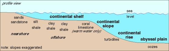
Being an “old school” geologist, the phrase, “Extended Continental Shelf,” struck me as a bit odd. By comparison, this is the nomenclature I was taught way back in the Pleistocene:
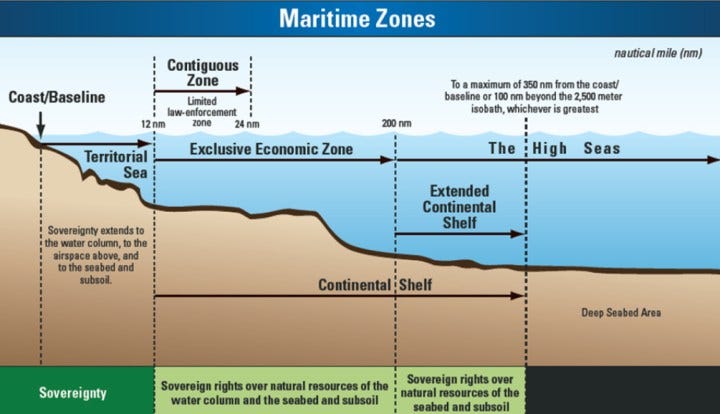
The USGS has a nice graphic explaining hw the Extended Continental Shelf:
Under the United Nations Convention on the Law of the Sea (UNCLOS) the continental shelf is that part of the seabed over which a coastal State exercises sovereign rights with regard to the exploration and exploitation of natural resources, including oil and gas deposits, as well as other minerals and biological resources of the seabed. The legal continental shelf extends out to a distance of 200 nautical miles from its coast, or further if the shelf naturally extends beyond that limit.
Under UNCLOS, the continental shelf evidently now includes the continental slope and continental rise.
Significance of an Extended Continental Shelf
The new mapping could allow the US to claim the seafloor and subsurface resources over the following areas:
Arctic Ocean 520,400 km2
Atlantic Ocean 239,100 km2
Bering Sea 176,300 km2
However, the vast majority of the geological resources (oil & gas) will be off limits to exploration and production.
“Sources/Usage: Public Domain. The 200-nautical mile U.S. exclusive economic zone is shown in dark gray on the map. The USGS CMHRP has collected sediment thickness data for defining the extended continental shelf—the shelf beyond 200 nautical miles—in the Arctic and Atlantic Oceans and the Bering Sea (yellow tracks).” USGS
Smaller areas offshore California and the Gulf of Mexico are also now eligible for ECS claims. Whoop-de-do! Obviously, with oil & gas activities largely prohibited in these areas, what geological resources have any value?
Geological Resources
The maps have also shed light on the geologic evolution of ocean basins, identified areas at risk of producing submarine mudslides that could trigger tsunamis, and pointed to potential seafloor mineral deposits.
Scientists from many fields also “piggybacked” on the mapping voyages, obtaining everything from seafloor rock and mud samples to one of the first bits of icelike gas hydrate—a potential energy source—recovered from the Arctic.
We can’t drill for subsurface oil & gas, however we can mine seafloor methane hydrates?
The Real Resources
Federal agencies, including the National Oceanic and Atmospheric Administration and the U.S. Geological Survey (USGS), ultimately spent tens of millions of dollars on nearly 50 mapping cruises, some held jointly with Canada. The ships completed multibeam surveys of 3 million square kilometers of sea floor and conducted acoustic surveys, which use sound to map sediments, along nearly 30,000 linear kilometers.
Meanwhile researchers are feasting on the data. For his 2020 doctoral dissertation, for example, Sowers used an algorithm to sort seafloor features along the U.S. Atlantic coast into habitat types, including mounds and seamounts that may host deep water sponges and corals. Such analyses, he notes, could help U.S. officials identify rich seafloor ecosystems that need protection.
They spent tens of millions of dollars, acquiring 3 million mi2 of geophysical data in order to claim an extra 1 million km2 of territory, evidently to place it off limits to economic exploitation. In conclusion, it truly does appear that their goal was to enable the US to claim more seafloor territory in order to protect if from capitalism.
I couldn’t make this sort of schist up even if I was trying.
That Said… The Science is Way Cool!
Technology and Innovation in Seafloor Mapping
[…]
The USGS designs mapping research programs to address a wide range of topics, and to expand our understanding of deep sea minerals, offshore energy, marine biological habitats, hazards, and more. The USGS uses acoustic techniques to collect detailed information about the seafloor, such as its shape, sediment composition and distribution, and underlying geologic structure and sediment type. Seafloor video, photographs, sediment cores, and other samples are also collected to validate the acoustics and provide a comprehensive foundation for studies of sediment and contaminant transport, landslide and tsunami hazards, gas hydrates, methane and carbon flux, benthic habitat quality, and sediment availability. Managers, policymakers, and other stakeholders use the map products derived from these studies to make informed decisions regarding the Nation’s safety and economic prosperity.
Graphic showing geophysical and sampling systems used to define the seafloor topography, surface sediments, and underlying geology. Sidescan-sonar systems acquire information about the surface of the seafloor, swath bathymetric systems measure the depth, or seafloor topography, seismic sources map the underlying geologic structure, single-beam echosounders map the depth at a point beneath the vessel, and sampling systems collect samples of the seafloor and can be equipped with digital camers and video systems to collect optical images of the seafloor.
The Bureau of Ocean Energy Management (BOEM) finally held Lease Sale 261. After months of legal battles over the fraudulent habitat claim for a fake whale species, Federal judges forced BOEM to hold the sale and drop all of the unlawful Rice’s whale restrictions.
Lease Sale 261 brings in more than $382 million in high bids
Dec. 20, 2023
Lease Sale 261 reported to be the largest oil and gas lease auction since 2015.
Offshore staff
NEW ORLEANS – The Bureau of Ocean Energy Management (BOEM) reports that Lease Sale 261 generated $382,168,507 in high bids for 311 tracts covering 1.7 million acres in federal waters in the US Gulf of Mexico.
BOEM says that a total of 26 companies participated in the lease sale, submitting 352 bids totaling $441,896,332.
Among the winners were Chevron, BP, Shell, Equinor, Repsol, Woodside Energy, Occidental Petroleum, Murphy Oil, Talos Energy, and Kosmos Energy.